Here is another real photograph postcard (RPPC) that recently caught my eye while I was browsing an online auction site. I was initially intrigued by the stately building in the middle ground of the image, so I decided to purchase it. Once it arrived in the mail, I began to search for clues that might reveal where this photograph was taken. The postcard is unused, so I didn’t have a postmark to work with, but based on the AZO stamp box on the back, I was able to place the date of the RPPC between 1904 and 1918.
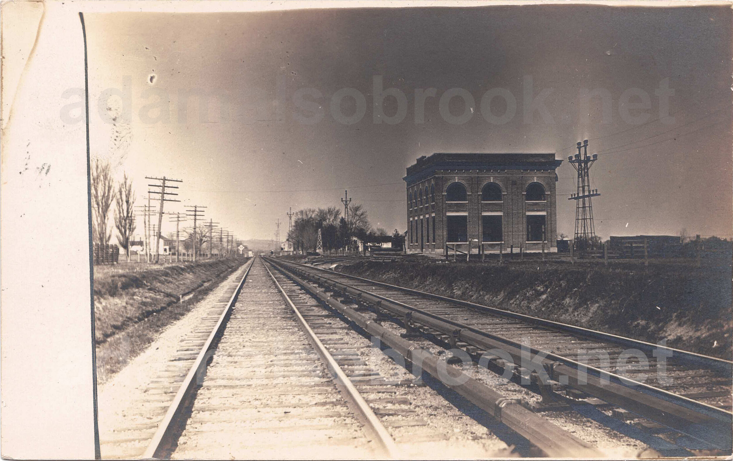
Electrical substation of the Oneida Railway Company at Minoa, New York. Real photograph postcard (RPPC), author’s collection. Based on the construction date of the third rail interurban line and the stamp box on the RPPC, this image dates from 1907 to 1918.
Now that I had a rough time period, I started looking for additional clues in the image that could help reveal the location of the building. I looked closer at the double railroad tracks, and the “third rail” power system along the side of the tracks offered the first clue. I looked online to see if I could track down railroad systems that used third rail power, and after a bit of a tedious search over a few days I was gradually able to narrow the location down to Illinois, Indiana, Ohio, and New York. I then took a closer look at the type of third rail power system shown in the photograph, and after some additional research I found that I was looking at an “underrunning” third rail configuration. With this type of third rail system, a contact shoe on the rail vehicle (usually mounted on the side of the truck) draws power by running on the underside of the power rail.
So now that I knew the type of third rail power system, I was eventually able to determine that the third rail installation shown in the photograph was the Wilgus-Sprague system, named for its inventors, Frank Julian Sprague (1857-1934) and William John Wilgus (1865-1949). Wilgus and Sprague filed for a patent on May 27, 1905, and they received United States Patent 908,180 on December 29, 1908. The Wilgus-Sprague system is most well-known for its role in the electrification of the New York Central’s lines running into Manhattan’s Grand Central Terminal, but use of their patented system on rural interurban lines was much more unusual.

United States Patent 908,180, granted to William John Wilgus and Frank Julian Sprague on December 29, 1908 (Google Patents).
I then began to look more closely at interurban systems in New York to see if I could find one that used the Wilgus-Sprague system. At this point, another clue hidden in the photograph came into play: the distinctive electrical distribution towers to the right of the building and then running off into the distance. I began searching for images of interurban railroads in New York to see if any other photographs showed these unusually-designed towers. After a bit of searching, I finally found a matching tower on another postcard from the era. The postcard gave the name of the interurban line as the “Oneida Railway Company,” and a little bit more research revealed that the Oneida Railway Company used the Wilgus-Sprague third rail system.
Now that I was armed with the name of the interurban company, I started looking for a map of the line to see if I could narrow down the location of the electrical substation building. I found a map of the route of the Oneida Railway Company, and I traced it on a modern aerial photograph. After about an hour of tracing the long-gone railroad line, I stumbled across a building at Minoa, New York that sure looked familiar:
After diving down this rabbit hole for several days, I was now reasonably certain that the RPPC in my collection was a rare image of the Oneida Railway Company substation at Minoa, New York. A few days later, I happened across another postcard of Minoa, New York that shows the west side of the substation and three houses to the north:

“Power House - Res. of Strodle, Lewis & Hessler - Minoa, N.Y.” H.A. Myer & Co., photographers, Jordan, N.Y. Real photograph postcard (RPPC), author’s collection. Based on the construction date of the third rail line and the stamp box on the RPPC, this image dates from 1907 to 1918.
After I pieced all of this together I set it aside for a few days. When I picked this research project back up today, I came across a Flickr page that gave me even more information about the Oneida Railway Company and confirmed what I had discovered.
Tip of the hat to “CNYrailroadnut” on Flickr: https://www.flickr.com/photos/97630304@N02/albums/72157646484078178.